Neighbourhood Plan Proposed Maps

A selection of maps taken from the joint Grasby, Searby cum Owmby Neighbourhood Plan Submission can be found on the parish maps page referenced below.
These include proposals on:
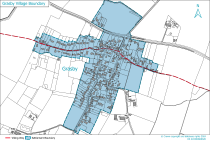
- Village Development Boundries. These boundries cover current village developments and the sites supported by the Parish Council for future development.
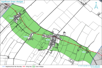
- Parish 'Geen Wedges'. These are defined as, ‘Open areas around and between parts of a settlement which maintain the distinction between the countryside and the built-up area.' They also provide recreational and wildlife protection. As such, there is a presumption against development within these areas.
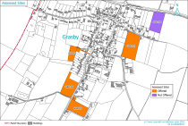
- Assessed Building Development Sites in the parish. This shows the independently assessed sites for future development up to the year 2040.
Please note: the current aim of the Parish Council is to hold a formal referendum of all residents on the legal adoption of the Neighbourhood Plan by the end of 2026.
Further detailed information on the proposed maps and much more besides, can be found here > GSONP.
| Village Development Boundaries |
|
Green Wedges |
|
| Assessed Building Development Sites |
|